 INSPIRE Geoportal
Aree tutelate - Siti Natura 2000 - ZSC
Confini dei siti di importanza comunitaria. SCOPO: Rappresentare le aree denominate Zone Speciali di Conservazione della Rete Ecologica Natura 2000.
Simple
- Date (Creation)
- 2011-11-09
- Date (Revision)
- 2022-01-13
- Citation identifier
- r_vda:01714-DATA
- Cited responsible party
-
Organisation name Individual name Electronic mail address Role Regione Autonoma Valle d'Aosta
u-cartografia@regione.vda.it cartografia@regione.vda u-cartografia@regione.vda.it
Owner RAVDA - Biodiversità, sostenibilità e aree naturali protette
areeprotette@regione.vda areeprotette@regione.vda.it
Author
- Presentation form
- Digital map
- Issue identification
-
r_vda:01714-DATA
- Point of contact
-
Organisation name Individual name Electronic mail address Role RAVDA - Ufficio Cartografico
u-cartografia@regione.vda.it cartografia@regione.vda u-cartografia@regione.vda.it
Point of contact
- Maintenance and update frequency
- Not planned
- GEMET - Concepts, version 2.4
-
-
protezione delle aree naturali
-
-
INSPIRE priority data set
-
-
Directive 92/43/EEC
-
Natura 2000 sites (Habitats Directive)
-
- Keywords
-
-
EU
-
- Use limitation
-
Nel rispetto del diritto di proprietà e di autore propri dell'Amministrazione regionale, legge n.633 del 22 aprile 1941, Protezione del diritto d'autore e di altri diritti connessi al suo esercizio, è vietata, sotto qualsiasi forma, la duplicazione, e/o riproduzione, la commercializzazione e/o la cessione a terzi dei dati ceduti, anche se parzialmente rielaborati.
- Access constraints
- Other restrictions
- Other constraints
- Nessuna Limitazione al Pubblico Accesso
- Access constraints
- Other restrictions
- Other constraints
- Nessuna Condizione di Accesso e Utilizzo
- Spatial representation type
- Vector
- Denominator
- 10000
- Language
- Italiano
- Character set
- UTF8
- Topic category
-
- Environment
))
- Begin date
- 2012-01-01
- End date
- 2030-12-31
Vertical extent
- Minimum value
- 530
- Maximum value
- 4800
- Supplemental Information
-
Server: GDB: ForestaleFeature dataset: AreeProtetteFeature class: SICAttributi:- CODICE- TIPO SITO- DENOMINAZIONE- ETTARI- PERIMETRO- AREA
- Unique resource identifier
- ED50-UTM32N
- Distribution format
-
Name Version geo+json 1.0
- Distributor contact
-
Organisation name Individual name Electronic mail address Role Ufficio Cartografico - Centro Diffusione Conoscenze Territoriali
u-cartografia@regione.vda.it cartografia@regione.vda u-cartografia@regione.vda.it
Distributor
- OnLine resource
-
Protocol Linkage Name WWW:LINK-1.0-http--link https://mappe.regione.vda.it/pub/GeoNavSCT/index.html?metadato=MTD005N0030
- OnLine resource
-
Protocol Linkage Name Web Map Service (WMS) https://geoservizi.regione.vda.it/geoserver/sctAreeProtette/wms?service=WMS&version=1.1.0&request=GetCapabilities
- Hierarchy level
- Dataset
Quantitative result
- Value
- 1.00
Conformance result
- Date (Publication)
- 2010-12-08
- Explanation
-
Fare riferimento alle specifiche indicate
- Statement
-
La cartografia è stata realizzata sulla CTRN in scala 10.000.
Metadata
- File identifier
- r_vda:01714-META:20160908:170947 XML
- Metadata language
- Italiano
- Character set
- UTF8
- Parent identifier
-
Aree tutelate - Siti Natura 2000 - ZSC
r_vda:01714-META:20160908:170947
- Hierarchy level
- Dataset
- Hierarchy level name
-
Dataset
- Date stamp
- 2022-01-13
- Metadata standard name
- Linee Guida RNDT
- Metadata standard version
-
2.0
- Metadata author
-
Organisation name Individual name Electronic mail address Role RAVDA - Ufficio Cartografico
u-cartografia@regione.vda.it cartografia@regione.vda u-cartografia@regione.vda.it
Point of contact
Overviews
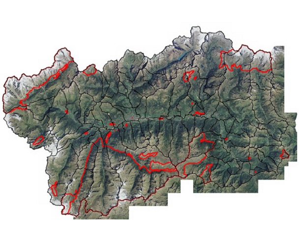
Spatial extent
Provided by
