 INSPIRE Geoportal
Groundwater level monitoring network - European reporting
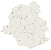
Brussels-Capital Region : location of the different groundwater level monitoring sites (or piezometric sites) managed by Brussels Environment under the surveillance monitoring of the groundwater status in accordance with the Ordonnance and the Water Framework Directive. Indication of the analyzed water body, the European Code and the Brussels code of the monitoring site.
Simple
- Date (Publication)
- 2007-07-09
- Date (Revision)
- 2012-12-31
- Date (Creation)
- 2007-07-09
- Citation identifier
- BE.BELB / BRU_ENVI_stationsGW_controles_2007.xml
- Point of contact
-
Organisation name Individual name Electronic mail address Role Brussels Environment geodata@environnement.bru geodata@environnement.brussels
Point of contact Brussels Environment geodata@environnement.bru geodata@environnement.brussels
Point of contact
- Maintenance and update frequency
- As needed
-
GeoBru Administrative Regions
-
-
Belgium
-
Région de Bruxelles-Capitale
-
-
GeoBru brussels keywords
-
-
Public Space
-
Reporting Inspire
-
-
INSPIRE feature concept dictionary
-
-
Environmental Monitoring Facility
-
- Spatial scope
-
-
Regional
-
- Access constraints
- Other restrictions
- Other constraints
- No limitations to public access
- Use constraints
- Other restrictions
- Other constraints
- Creative Commons Attribution (CC-BY) - required citation of data source. The full license is available here: https://creativecommons.org/licenses/by/4.0/legalcode
- Spatial representation type
- Vector
- Denominator
- 500
- Language
- Français
- Language
- Nederlands; Vlaams
- Topic category
-
- Structure
))
- gml32:beginPosition
- 2007-01-05
- gml32:endPosition
- 2024-01-01
- Unique resource identifier
- EPSG:3035
- Distribution format
-
Name Version GML
- Units of distribution
-
B
- Transfer size
- 1
- OnLine resource
-
Protocol Linkage Name WWW:DOWNLOAD-1.0-http--download
https://wfs.environnement.brussels/belb_inspire?SERVICE=WFS&VERSION=1.0.0&REQUEST=GetFeature&TYPENAME=bruenvi_water_monitoring_groundwater_level_reporting bruenvi_water_monitoring_groundwater_level_reporting WWW:LINK-1.0-http--link
https://ows.environnement.brussels/be_wms?Service=WmS&Request=GetCapabilities bruenvi_water_monitoring_groundwater_level
WWW:LINK-1.0-http--link
https://ows.environnement.brussels/belb?request=getcapabilities&service=wfs&version=1.1.0 Service de téléchargement - Bruxelles Environnement
- OnLine resource
-
Protocol Linkage Name OGC:WFS
https://wfs.environnement.brussels/belb_inspire?SERVICE=WFS&VERSION=1.0.0&REQUEST=GetCapabilities bruenvi_water_monitoring_groundwater_level_reporting
- OnLine resource
-
Protocol Linkage Name OGC:WMS
https://wms.environnement.brussels/belb_inspire?SERVICE=WMS&VERSION=1.3.0&REQUEST=GetCapabilities bruenvi_water_monitoring_groundwater_level_reporting
- Hierarchy level
- Dataset
Conformance result
- Date (Publication)
- 2010-12-08
- Explanation
-
The dataset does not fullfill the minimal requirements
- Pass
- No
- Statement
-
Bruxelles Environnement / Leefmilieu Brussel
Metadata
- File identifier
- stationsGW_controles_2007.xml XML
- Metadata language
- Français
- Character set
- MD_CharacterSetCode_utf8
- Hierarchy level
- Dataset
- Date stamp
- 2024-03-08T13:01:21
- Metadata standard name
-
ISO19115
- Metadata standard version
-
2003/Cor.1:2006
- Metadata author
-
Organisation name Individual name Electronic mail address Role Brussels Environment geodata@environnement.bru geodata@environnement.brussels
Point of contact
- Other language
-
Language Character encoding Dutch; Flemish UTF8 English UTF8 French UTF8
Overviews

Spatial extent
Provided by
